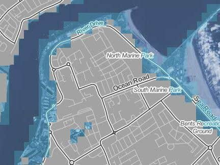
This map shows which South Shields streets will be submerged if sea levels rise


Developed by Climate Central, an independent organisation of leading scientists and journalists, the interactive tool known as Surging Seas allows users to input their hometown and observe the impact a rise in temperature could have on sea levels.
At the Paris agreement 194 states and the European Union signed an agreement which would set the long-term goal of keeping temperature rises down to 2C - despite these measures the rise could still see large parts of South Shields submerged by rising sea levels.
Advertisement
Hide AdAdvertisement
Hide AdAccording to Climate Central a 2C rise in temperature would see Sea Road overcome by the sea itself, along with South Shields Pier.
Further inland River Drive, Jarrow Road and sections of Temple Town could all be overwhelmed by a rise in sea levels.
At current rates the world's temperature is set to rise to 3.8C by 2100, according to the Climate Action Tracker - this would cause even more devastation to South Shields, according to the Surging Seas map.
A 4C rise in temperature would see the River Tyne encroach on residential areas, with water levels reaching as far inland as Forest Road and William Street.
'Rigorous research'
Advertisement
Hide AdAdvertisement
Hide AdAccording to Climate Central their map "strives to provide accurate, clear and granular information about sea level rise and coastal flood hazards both locally and globally, today and tomorrow.
"Anchored in rigorous primary research, our work distinguishes itself by its user-friendly maps and tools, extensive datasets, and high-quality visual presentation.
"The program dedicates its efforts to helping citizens, communities, businesses, organisations, and governments at every level to understand the consequences of different carbon pathways and to navigate the shifting waters of our warming world."
You can check how your hometown and address would be affected with the Surging Seas map at choices.climatecentral.org