North East braced for cold snap as Met Office issues snow and ice warnings
and live on Freeview channel 276
Met Office forecasters issued a yellow warning for ice at 4pm on Friday, January 29, with the alert due to run until 11am on Saturday, January 30.
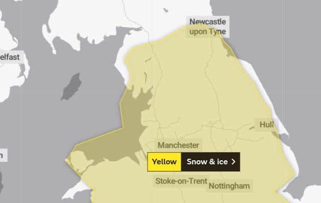
And a separate snow and ice warning is also coming our way from midnight on Tuesday, February 2. At present, it will remain in place until 11.59pm on Wednesday, February 3.
Advertisement
Hide AdAdvertisement
Hide AdA Met Office statement online added: "Snow, with a risk of widespread ice, is likely to push slowly northeast from late Monday, bringing difficult travel conditions.”

While the region’s temperatures are forecast to reach 5°C between Monday and Wednesday, it will feel much colder – barely getting above freezing at some points.
Met Office deputy chief meteorologist, Jason Kelly, added “On Sunday we see another weather front bringing rain and snow east and north across the UK, but the most significant event in the forecast is a feature from late Monday evening, which threatens to bring rainfall across a swathe of the UK from the south and west.
"In the colder air to the north of this system the rainfall will readily turn to snow or even freezing rain, affecting a large part of England and Wales north of the M4 corridor.”

Advertisement
Hide AdAdvertisement
Hide AdMet Office Chief Meteorologist, Steven Ramsdale added: "The most significant event in the forecast is a feature from late Monday evening, which threatens to bring rain and some snow across large parts of the UK.
“Yellow weather warnings have been issued for Tuesday and Wednesday highlighting the risk of disruptive snowfall with the high ground of northern England and Scotland most likely to see the largest snow accumulations.
The Met Office has provided a list of things to expect while the weather warning is in force, including possible delays on roads, cancellations to public transport services and potential power cuts in worst-hit areas.
Members of the public are also urged to take caution when using untreated pavements and cycle paths as the icy surfaces could lead some people to fall and suffer an injury.
Advertisement
Hide AdAdvertisement
Hide AdFollowing the cold snap, Met Office forecasters are predicting that the weather will start to become drier from Thursday, February 4.